The Port Orford region has the potential to be affected negatively by climate change. Some of the dangers include:
An increase in annual air temperatures
Extreme precipitation
Coastal erosion and inundation
Single disaster events influenced by these climate change characteristics include but are not limited to:
Winterstorm
Flooding
Landslide
Wildfire
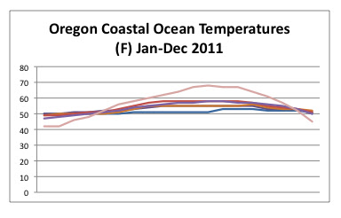
The general indications of climate change for the area suggests flooding, sea rise and increased air and sea temperatures causing more cyclonic activity in the region. Extreme events are more likely given the increase of Greenhouse gas emissions.
Impacts to the area are going to be relatively small as the community itself is extremely small. The area does not produce any significant product that would alter any particular changes in another area either.
Background:
These events can serve as a considerable problem for Port Orford. According to the IPCC Synthesis Report (2007) sea level rise has been happening since 1961 and 11 of the past 12 years have been the warmest yet. "There is high confidence that some hydrological systems (in North America) have also been affected through increased runoff and earlier spring peak discharge in many glacier- and snow-fed rivers and through effects on thermal structure and water quality of warming rivers and lakes." This change can promote a disturbance of the local species and habitats by dynamically changing the environment in which they live. Below are the indicated changes as reported from the IPCC Synthesis Reprot.
Though this is a broad scope of the issue, the trends are still relevant. Below is a more local perspective of CO2 influences into the environment. This is data from the Oregon Climate Change Adaptation
Framework. A more local scale is important to consider when talking about climate change as deposition can vary form region to region.
This syntesis report states unequivocally that the main cause to global warming is human induced. The report shows the following diagram to support this claim.
As a result of this carbon emission and inundation into the atmosphere, there are inevitably going to be some consequences. The IPCC shows the increase in average temperature for North America. The relationship to an increase in CO2 and increased average temperatures shows some anthropogenic relationship. The next diagram shows the global relationship.
Global warming and sea level rise or the obvious and most popular consequences from CO2 and greenhouse gas emissions. Other more relevant consequences do exist as well. The IPCC Synthesis reprot claims there is a "very likely increase in frequency of hot extremes, heat waves and heavy precipitation (and a) poleward shift of extra-tropical storm tracks with consequent changes in wind, precipitation and temperature patterns." Such consequences are relevant to Port Orford Oregon as most weather patterns already exist and are somewhat familiar. With climate change, the preceding variables would have severe consequences for the local area. Ocean acidification would also serve as a severe threat to the Port Orford Cedar Forests as the uptake of precipitation from the ocean would subsequently be released over the coastal forests before going up and over the Cascade mountain range. The result of sea rise for Port Orford is particularly hazardous as IPCC indicates there will be a 30% loss of coastal beaches across the globe in the next 100 years.
Economically speaking, Port Orford is a struggling community, a small town in southern Oregon once based on Logging now has no expectations for growth and the main source of income is from tourists. As a small community though, they have the capacity to watch out for each other and provide assistance to those who need it most when disasters to occur. The following diagram shows the potential threats to Oregon's Coastal areas.
With an increase of variability in weather patterns, certain possibilites to new and disasters need to be accounted for. In Port Orford, the town is doing just that and strengthened providing some consideable mitigation efforts.
Above is the CCCAP's action plan. An excerpt from the city addendum explains
"The city of Port Orford developed this addendum to the Curry County multi-jurisdictional Natural Hazards Mitigation Plan in an effort to increase the community’s resilience to natural hazards. The addendum focuses on the natural hazards that could affect Port Orford, Oregon, which include: coastal erosion, drought, earthquake, flood, landslide, tsunami, volcano, wildfire, and severe winter storm. It is impossible to predict exactly when disasters may occur, or the extent to which they will affect the city. However, with careful planning and collaboration among public agencies, private sector organizations, and citizens within the community, it is possible to minimize the losses that can result from natural hazards."
The City has taken special precautions and included a majority of the towns public services in order to create a comprehensive vulnerability assessment plan. Flood plains have been assessed and are now officially part of the City's planning coordination, wildfire coordination plans are now intact, Port Orford's transportation plan is now in place and creating an outreach team for educational facilites to provide information in the event of a disaster and the Community Economic Development Plan is geared towards a disaster conscious framework for development. In the event of a Tsunami, the City has outlined the area of the City that is most prone to disaster.
The mitigation efforts taken on by the City of Port Orford are valuable to the community and should be held in high regard as an exemplary city taking into account the value of its citizens and formally accounting for the processes necessary to carry out a plan of this nature, especially for a town of 1200 people.
Discussion
Though Port Orford is a coastal community more prone to some significant weather pattern changes and anomalies, this wouldn't be a bad place to be in the furutre given there was several access points to get in and out of.


