Blog Post #2

Air masses of Port Orford
Port Orford experiences mP fronts that have formed over high latitude oceanic regions. While in the winter, this area experiences cP air masses that while cool and moist are also unstable. The result is the formation of warm occlusions providing the orographic lift from the mountain range to the east providing the precipitation that is so typical of the area.
Impacts of the Jet Stream on Air Masses
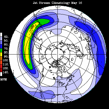
A jet stream is an area of strong winds ranging from 40-140 MPH. These can be thousands of miles long extending across continents effectively impacting weather patterns. These jet streams are considerable means of transport for the weather patterns experienced in any location.
Precipitation and Air Masses
As a rule, air masses are not associated with precipitation. However, with the orographic lifting of the area, the relationship is apparent. The image below shows the annual precipitation of the area. The county at large receives moderate to above normal precipitation. What is interesting to note are the areas closest to the coast that receive the least amount of rain. With an increase in elevation, there is an increase in precipitation.

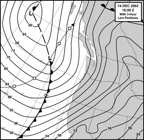
Occluded Fronts of Port Orford

This location experiences cold occluded fronts on a regular basis. Below is an example of a cold front in with a cold type occlusion reaching the western coast of the US in December 2002. This is an example of strong storm development that can occur in these conditions.
The 3 satellite images below show today's imaging from the National Weather Service
This water vapor image shows short wave troughs and jet streams as well as upward vertical motion.

Visible light

Infrared

How Fronts are affecting the biology of the region
Link to PDF about fronts and plankton around Port Orford OR
Abstract:
Foam lines oriented parallel to shore are common features of rocky shores. At times, the water coloration is different on either side of the foam lines, suggesting they are associated with fronts. We investigated the effect of shore-parallel foam lines and associated fronts on distributions of holo- and meroplankton. We performed CTD transects to describe the fronts and carried out vertical zooplankton tows to describe the distribution of zooplankton relative to the fronts. Fronts were within tens of meters of shore and were apparently generated by the interaction of coastal currents with local topography. We sampled four sites (three coves and one open coastal site), some of which were separated by only a few hundred meters. At each site we found shore-parallel foam lines and associated thermal fronts, but the characteristics of the fronts were different at three sites, suggesting that three different mechanisms were generating the fronts. At two coves, the foam line and front appeared to be due to the interaction of wind-driven currents from the north with coastal topography. At the third cove, the front appeared to be due to the expansion of solar-heated surface waters out of the cove. The foam line and front at the open coastal site appeared to be due to boundary mixing. At the coves, the distributions of holoplankters, meroplankters and phytoplankton were clearly altered by the presence of the fronts. At the open coastal site, the front had less effect on the distribution of zooplankton. The coastal ocean is the source of new recruits to the intertidal zone and an important source of food in the form of phytoplankton for filter feeders. We hypothesize that these very nearshore fronts may play an important role in structuring intertidal communities with which they are associated.
Misc Links
This link shows a current animation of the Western US satellite image-visible
This link shows a current animation of the Western US satellite image-infrared
Shows US map of wind direction and wind speed
No comments:
Post a Comment